Функция поиска мин/макс высот на местности.
fnc_getTerrainHeightASL
Used scripts:
1.Creating spiral - Author: ArseniyK
2.Sort a numeric array - Author: VVL99
Credits & Thanks: ArseniyK, VVL99
/*
File: fnc_getTerrainHeightASL.sqf
Author: Dimon UA
Used scripts:
1.Creating spiral - Author: ArseniyK
2.Sort a numeric array - Author: VVL99
Credits & Thanks: ArseniyK, VVL99
Description:
Function to find maximum/minimum heights of the terrain
Parameter(s):
_this select 0: position (Array)
_this select 1: step (Number)
_this select 2: count (Number)
_this select 3: true - maximum heights, false minimum heights
_this select 4: the size of the returned array (Number)
_this select 5: debug (true - otional)
Returns:
Array - format PositionASL
*/
private ["_pos","_step","_count","_sort","_size","_debug"];
_pos = _this select 0;
_step = _this select 1;
_count = _this select 2;
_sort = _this select 3;
_size = _this select 4;
if ((count _this) > 5) then {_debug = _this select 5;}else{_debug =false;};
//=============Creating spiral=============//
step = _step;
a = -0.3*step;
posx = _pos select 0;
posy = _pos select 1;
x = 1;
y = 1;
arr = [[posx,posy, getTerrainHeightASL [posx, posy]], [posx+step, posy, getTerrainHeightASL [posx+step, posy]]];
for "_i" from 0 to _count do
{
r = sqrt (x*x+y*y);
tx = a*x+r*y;
ty = a*y - r*x;
len = sqrt(tx*tx + ty*ty);
k = step/len;
x = x + tx*k;
y = y + ty*k;
arr set [_i+2,[x+posx,y+posy,getTerrainHeightASL [x+posx, y+posy]]];
};
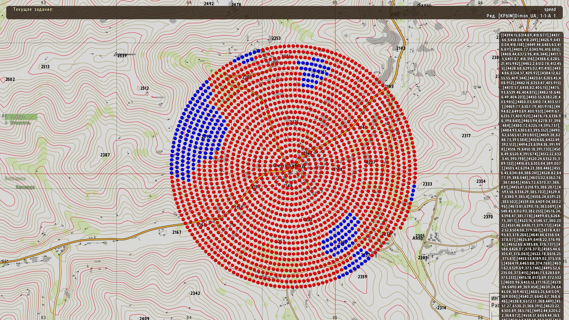
if _debug then
{
{
call compile format ["
_m%1 = createMarker[""markerRed%1"",[ _x select 0,_x select 1]];
_m%1 setMarkerShape ""ICON"";
_m%1 setMarkerType ""DOT"";
_m%1 setmarkercolor ""colorred""; ",_forEachIndex];
} foreach arr;
};
//==========Sort a numeric array=========//
_res_sort = [];
{
_k = _x;
_s = _x select 2;
_s_pos = 0;
{
if _sort then
{
if (_s < (_x select 2)) then
{
_s_pos = _s_pos + 1;
};
}else{
if (_s > (_x select 2)) then
{
_s_pos = _s_pos + 1;
};
};
} foreach arr;
_res_sort set [_s_pos,_k];
} foreach arr;
_res_sort resize _size;
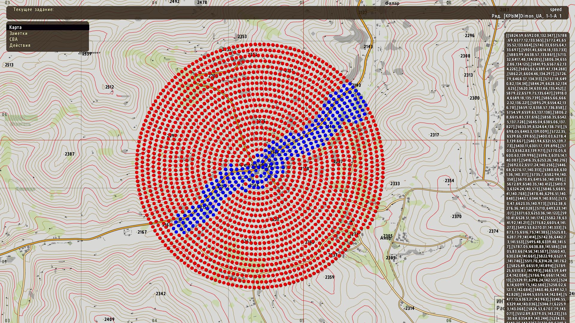
if _debug then
{
{
call compile format ["
_m%1 = createMarker[""markerBlue%1"",[ _x select 0,_x select 1]];
_m%1 setMarkerShape ""ICON"";
_m%1 setMarkerType ""DOT"";
_m%1 setmarkercolor ""colorblue""; ",_forEachIndex];
} foreach _res_sort;
// hint str _res_sort_p;
// copyToClipboard str _res_sort_p;
};
Код
fnc_getTerrainHeightASL = compile preprocessFileLineNumbers "fnc_getTerrainHeightASL.sqf";
[getpos player,20,2000,true,200,true] call fnc_getTerrainHeightASL;
Самые высокие точки
самые низкие
fnc_getTerrainHeightASL